Showing posts with label Battery. Show all posts

Wednesday, January 25, 2017

2010 - Slesse Memorial, Rockies With Lynn, Alouette, Diamond Head, Icefield Parkway, Lake O'Hara

My Flickr site for more pictures - 

Mt. Slesse Memorial

Location of the memorial


East side of Slesse

In early June my friends Ken and Paula and I went up to the Mt. Slesse memorial. We found the new trail and made our way up to the plaque. What was particularly interesting about this hike besides the good conversation, was the amount I learned about the plants along the trail. It was really interesting to see the large variety of plants and the different stages of development of the same plant depending on the elevation.


The Rockies With Lynn


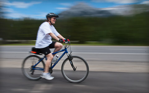
Lynn on the Canmore-Banff bicycle path.
In ealy July Lynn and I went off to the Rockies with our bikes. We spent three nights in Canmore, doing some easy mountain biking and sampling restaurants we hadn't been to before. :-) After that, we drove up the Icefield Parway, stopping off at a number of places including Mistaya Canyon and then on to Jasper where we spent three nights in the Pine Bungalows where we did some more easy biking. It was a very enjoyable time. 


Alouette or Battery?


In mid July my friend Ken and I went up Battery Mountain. Or should I say Alouette Mountain? In any event, it was good to feel that I could still do the hike and not have painful knees at the end. Granted, I wore my knee brace on the way down. :-)

Diamond Head


Paula with Mamquam in the background.
At the beginning of August Paula and I went for a day hike up to Diamond Head. The weather was great and the Tiger Lilies and other various flowers were out. 


The Icefield Parkway - Again! :-)

It's a frog.  Don't ask. ;-)
I have had the privilige of cycling the Icefield Parkway with my good friends a number of times before. The first time was with Ken in 1996 when we started Shuswap Lake and cycled up the Yellowhead highway to Jasper, south to Lake Louise, then over the Roger's Pass back to Shuswap Lake. After hearing about our great adventure, in 1998 our friends Dale and Chuck joined us on the same ride, but in the opposite direction, but also including a variation including Radium and the Kootenay Valley. The Golden Triangle part was popular enough that in 1999 we did just that with a new group of friends. These were all unsupported rides where we used panniers to carry tents, sleeping bags, etc. In 2003, Dave, Chuck, and I did just the Icefield Parkway - Jasper to Lake Louise and back, panniers and all. It was another great ride. We even got to know Michael and Regula, a Swiss couple cycling around the world. In 2009 we attempted to do a car supported ride from Jasper to Lake Louise and back, but were met with lousy weather at Saskatchewan Crossing.

Ken and Chuck
So here we were again, my good friends Ken and Chuck, with my CRV packed full of camping and bike gear and finding ourselves on another Jasper to Lake Louise and bike ride. This time supported with my car. We changed drivers every forty-five minutes and it worked very well.  Chuck had his folding Bike Fridayand thoroughly enjoyed it, just as he had the month before in France. We have all become interested in photography, so photo ops presented themselves every time it was our turn to drive. We had fun and in spite of the forest fire smoke on the return leg, the weather was very good. It got so smoky though that on our drive west of Jasper, the visibility dropped at times to less than a kilometer!

Lake O'Hara -  Canadian Rockies
Ken Willis
Ken kindly made reservations for the Lake O'Hara campsite sometime in June, and by the time we were ready to go, Chuck had to stay home to help sell his house. So off Ken and I went to an area we had never been to before. I had read and seen quite a bit about it and was really looking forward to it.

We spent our first night in Golden and were at the parking lot in plenty of time for the 8:30 bus. We spent three nights and got some good hikes in between the showers due to the unsettle weather. The first day Ken and I went up to the Opabin Plateau, and then along the Yukness Ledges to Lake Oesea. From there I headed down with a sore knee and Ken continued on to the Wiwaxy Gap and then down the steep trail back to Lake O'Hara. 
The second day I rested my knee and spent three or four hours slowly going around Lake O'Hara doing photography while Ken went and did the All Souls Prospect section of the Alpine circuit.

Ken and Keith
The third day started with showers and we made our way up to the AAC cabin taking pictures and then eventually we found ourselves at the high point on the trail to Lake McArther. We made our way down to the Lodge for afternoon tea and watched another shower from the comfort of padded seats. :-)
During our last night it rained all night and by the time we rode the bus down the road back to our car we had resigned ourselves to the fact that staying on another day as hoped made no sense with the poor weather. Besides, Ken could use the time back home preparing for his upcoming trip to Morocco!
Retirement can be a very busy time! ;-)


Monday, January 23, 2017

2008 - Diamond Head, "Photo Shoot", Battery via Evan's Valley


Diamond Head in March
Red Heather shelter
Chris Cooper and I walked from the chain up spot because of a "road closed" sign partly blocking the road, but after walking up to the normal parking lot, I think I could have chained up and taken the CRV up the "closed" section. As we approached the big lump in the snow which is the Red Heather shelter now, I sensed smoke! Yea, a warming fire! As we ate and drank it snowed harder and harder. Note the lack of view out the window.
We actually had to pole numerous times on our way down. For those of you who are familiar with this ski, you know how unusual that is! A little Ebrake and ABS to deal with the slippery road on the way down, and it was Tim Hortons for us! My fifth time to Diamond Head this season, and another enjoyable workout in the hills.

Manning Park Photo Shoot
Location of Manning Park Lodge


My home for two nights

Well, it was early April and the weather forecast was great, but nobody was able to go to Manning Park with me. What to do? I realized that if I didn't go by myself I would regret it and later consider myself a whimp. Besides, I wanted to learn more about photography and my new digital slr and Manning Park offered a lot of picturesque terrain to practice on. I was finding it very enjoyable to learn more about photography. I wanted to get beyond the "snapshot" stage and had recently joined The Clear Focus Camera Club and they had been very welcoming. I had also enjoyed talking with my friend Les Raskewicz about photography and wanted to try to put theory into practice.


Manning Park downhill ski area looking at Mt. Hozameen.
I made it up to Manning Park by the early afternoon and the lifts were shut down for the season, so I hiked up to the top of the orange chair to get a view of Mt. Hozameen. It was cold and windy and the lift shack at the top provided welcome shelter. It was clouding up a bit and since I wasn't happy with the colours I got, I converted the pictures to black and white. 

Mt. Hozameen
I have a vibration reduced18-200 zoom and I was curious what I would get hand held, especially since I was chilly and it was windy. The picture above was taken at the full zoom of 200mm and was hand held. I guess the vibration reduction really works!

frost

milk and red


Reaching
The next day I went for a walk on the trail that heads to Windy Joe. It was a treat to be able to go slowly, looking for interesting things to pay attention to. One of the more interesting things was the shapes and colours created in the partially frozen streams crossing the trail. 


After the Windy Joe trail, I took a drive to the Monument 83 trail head. I walked to where the trail crosses the river and found the colours of the river and bridge interesting. Although the picture above is fairly standard, I found the shadow pattern on the river interesting.


Growing Crystals

On my third day, I took a walk up the Fat Dog trail that eventually leads on the Three Brothers area. About a kilometer from the parking lot, you cross a stream. Here I found a few interesting shapes and colours. Yes, I know the picture is in sideways. I find it more interesting this way. :-)
Three days and two nights in a tent by myself. Minus 12 in the morning. Listening to podcasts and sipping brandy to while the evening along all snug in my down sleeping bag. Learning more about the features of my Nikon D80, learning more about editing in camera raw, and learning more about Photoshop CS3. It's all good. 
I had a good time and look forward to my next "photo shoot".

Keith

Alouette (Battery) Mountain via Evan's Valley - a solo trip by Alan Lizee
Location of Alouette Mountain

Alan Lizee makes a solo trip up Evan's Valley, then up a north facing gully between Battery and Evan's Peak (Sugar Loaf to some of us).  


In Evan's Valley with Blanchard Peak in upper left from the west branch of the creek.
I don't know why I always choose the options that take a few days of recovery. Anyway, after waiting-out the big snow dump over the last few weeks, I was chomping at the bit for some punishment. I hiked up Alouette on Wednesday by way of Evans Creek and the North gully to gain the North-East ridge above the big buttress. I went home, over what John Hume calls, false peak, then on down the Viking Creek rib to make a loop around Evans Pk. It was extremely tough going up the gully, and there were times when I had to rest after only 15 steps - and some of those had negative elevation gain. It took 4 3/4 hrs to summit, going down took less than 2 casual hours as the snow was nice for downhill on snowshoes. Avalanche activity was extreme. Edge roared continuously. The buttress beside me dumped four times, and there was an all-day, continuous hiss of graupel cascading down its flank. Sometimes it flowed around me as an inch-deep, whizzing river - it was awesome! 


The friendly gully and the big, hissing buttress

The bottom gulley
Half way up the gully, I used the ski pole like I was cross-checking with a hockey stick to keep from sinking too deeply, I knew that if I stopped to take a photo, things would start happening, sure enough, the buttress dropped its first load, notice that I took the fall line on a rise far away from the buttress

Looking west towards Battery.

Two blurry gullies on the buttress are the remnants of the first dump, notice that I am well away, and I have good terrain protection above.


Sunday, January 22, 2017

2007 - Nickel Plate, Battery Mountain, Golden Ears, Baffin Island

My Flickr site for more pictures - 

Nickel Plate - Penticton
Location of Nickel Plate Nordic Centre


The lodge
My good friend Alan Lizee and I headed up to Penticton on spring break to do some cross country skiing with Bob Cuthbert. Nickel Plate is a little less than an hour from down town Penticton and is close to 6000 ft. above sea level, so it is a lot colder than down in the valley. 


Alan and Bob

The weather was wonderful. It was well below zero, and the sun was out. The tracks were set, and there was lots of snow. The wood stove was burning in the hut waiting for our return. What more could I wish for? I wished I was in shape! Oh, well, we had a good couple of days and it was thoroughly enjoyable. After our second day of skiing Alan and I drove down to Oliver to see Lanny and Julie Martiniuk and enjoyed their company for the night. (Keep an eye out for Stoneboat wines) 


Battery Mountain via Viking Creek
Location of Battery and Evan's Peak trail


Alan and Chris
"I always thought only a masochist would dare wander up the bushy, bluffy flank of Evans Peak, in Golden Ears Park, until I read a bivouac.com report by Fred Douglas. He and Alice climbed Evans Peak, accessing it from a gully rising out of Evans canyon. On their descent they noticed flagging in the col between Evans and Alouette, and being adventurers, they decided to find out where the tapes would lead them. They headed down a prow between Viking creek and its neighbor creek to the North, and they ended up on the Viking Creek lookout trail. It took 90 minutes to descend from the col to the West Canyon hikers' parking lot."
- Alan Lizee

Lots of snow

"I decided to set my prejudices aside and try to get up Alouette from this access. It turned out to be a quite enjoyable snow hike, winding around a few bluffs and trending generally Westward to gain Alouette's South West ridge. Here we found the snow hiking to be more pleasurable by staying to the East of the summer trail, closer to the actual ridge crest. Chris Cooper and I summited first, then I repeated the hike twice more In April with members of the Ridge Meadows Outdoor Club.

This being the year of the big Fraser River flood threat, I thought a picture of the mid-April snow profile at 1150 meters would be appropriate."
- Alan Lizee

Chris Cooper hiking across the top of  Alouette (Battery) Mt. summit

Blanchard Peak (Needle Point), Chris Cooper, Edge Peak


Golden Ears - Golden Ears Park

Looking north from the summit of the Golden Ears
Alan made a solo trip up to the summit of the Golden Ears May 31. Here is what he had to say:
"Hi Gang, I had to go back to the Ears today, Wednesday, because the weather was irresistible, and because there was unfinished business to get done. I hiked without a break to reach the summit before noon. I planned to just take 2 shots from the top and head right back down before the snow softened too much and maybe start sluffing. I ended up spending 20 minutes on top, and did run into a bit of a glitch coming down. The solution worked very well and I was down in no time. It was a wonderful day!
Happy Trails...Alan"


Blanchard Peak (Needle Point) looking south from the top.

In the picture above, Mt. Edge is off the left edge of the photo. Needle Point is the tooth like peak hiding Battery Mtn behind it. The southern part of the Golden Ears is on the right side.

Baffin Island Ski Expedition - May 08 to June 05 2007
Location of Baffin Island
The following article was written by Chris Cooper:

"A very typical camp with great views all the time"

"One more excuse to visit the Canadian Arctic, this time it is Gibbs Fiord on Baffin Island, at 70 degrees Latitude, the team composed of two fellows Chris Cooper, Manrico Scremin and three gals Liz Scremin, Linda Bily and Julia Keenliside.


Liz and Manrico and I had discussed a few years ago to do something in the Arctic on skis but it took a few years to finally pull it off together. Most of my Arctic journeys have been with John Dunn, Sandy Briggs and Mike Sharp so this will be a more modest trip and not too ambitious, having said that it’s great just being out their with new comarades.


This was the first Arctic ski trip for the others so they learned a lot from the old boy!!


Anyway, one must plan on at least a weeks travel time both going and returning on these types of journeys and also one must plan on having some complicated logistics to sort out including using points to your advantage!! It's the only way to get there!"


The group.


"We arrive in Iqaluit on the 9th May and met with Mary Potyrala who just happened to know Mike Sharp, Mary put us up for two nights then onto Clyde River to meet outfitter Levi Palituq who arranged Komatik and Snow machines for our group and moved us and gear to Gibbs Fiord.

A 10 hr journey by Komatik ( sled ) is cold, rough and quite adventurous but we managed to get there with some incredible scenery to say the least."


A sense of scale


"Our three week ski traverse starts here at Gibbs Fiord with walls as high as 5000ft.inplaces, very impressive.

The ski traverse took us through Gibbs Fiord, Stewart Valley, Sail Peaks, Walker Arm, Sam Ford Fiord, Polar Sun Spire,Swiss Bay, Revoir Pass and finally Eglinton Fiord. Levi arranged our pickup near Eglinton Tower which was about 60km from Clyde River."


Family in mind.


"In all I calculated 200km on skis including side trips, which was considerably less than most ski journeys up there and was considerably easier than the marches with John Dunn who we met heading North to Pond Inlet over a 6 week journey. It was great to see John, Sandy and Paul there."


"My last day trip on Baffin."

A Word About Global Warming as of January 1st 2008
"I have just picked up the phone just thinking of our dear friends in Clyde River, I spoke with Levi Palituq and he mentioned to me that there is no evidence of Global warming at present and that it has been consistantly cold temperatures of -40C and will be colder in January and February, It was completely dark December 18, 19, and 20th 2007.

They and the community have celebrated Christmas over a two week period starting in mid December, they came together with lots of music and dancing.

So there we are, another great journey on skis to a marvelous place in Canada’s Arctic."

Submitted on behalf of the group.      Chris G. Cooper


Saturday, January 21, 2017

2002 - Diamond Head Ski, Biking Golden Ears, Biking Rockies, Harrison Hot Springs Bike, Chilko Lake, Battery Mt., Manning Park

Diamond Head Ski
Location of Round Mountain - high point of the ski
My Flickr site for more pictures - 


Mamquam Mtn.
I skied up the old road to Diamond Head with my overnight pack another time. I have done it so often the route feels as familiar as a well worn hat. Sandy Briggs, Chris Cooper and I spent the first night in the Elfin Lake shelter, and the second night on the very top of high point.


Sunrise at high point.
The weather had been cloudy, but as we started the second night on the ridge top the clouds parted to expose a wondrous landscape. The morning dawned with a spectacular sky.
And some people ask why we do these things!

Mountain Biking in Golden Ears Park

Starting point of the ride at Gold Creek
Keith Akenhead


In this picture Keith Akenhead stands on an old east canyon road very close to the rocky beach on Gold Creek that provides a view of the backside of the Golden Ears. It is a good workout as you do a fair amount of climbing on the way up to the high point of the old road. You can also continue up Gold Creek on a trail and do some "rugged biking".


Cycling in The Rockies - July

Location of the old highway

Lynn Rajala


After I finished with my Simon Fraser University Tlite course in early July, Lynn and I packed up the van with camping supplies and our mountain bikes and headed for the Rockies. We spent some time in Kannanaskis Park and then went on to Lake Louise where we spent a couple of days. In the picture to the left, we rode the old road between Lake Louise and the access road to Lake O'hara. It was only about a kilometer to the West Lake Louise Lodge from there for lunch. It was a very enjoyable round trip.

From there we drove to the West Edmonton Mall. We made the drive home in one very long day.

Harrison Hot Springs Bike Tour

Location of Harrison Hot Springs

Chuck, Randy, Dave


Our campsite at Harrison Hot Springs.
Chilko Lake
Location of Chilco Lake
Denise and Robbie Needham


I went on a week long canoe trip organized by Chris Cooper to Chilko Lake, a high alpine area between Williams Lake and the coast. The canoe was thirty-seven feet long and was even rigged with a sail for the trip back from the southern end of the lake.


Chris Cooper

A beautiful area with ten thousand foot peaks all around the southern end of the lake. It's also grizzly bear country, but we didn't see any. The lake is about eighty kilometers long. The southern end is in typical wet west coast mountains that are heavily glaciated, with the northern end in the much flatter and drier interior region. A big change in a fairly short distance. An area not often visited due to its remote nature and the serious storms and associated waves that can build up on the lake.

Chris Cooper at the rear returning us to Tsilos Park. Turtle Island in the background.


Battery Mountain (Alouette Mt.) - August
Location of Alouette Mtn. (Battery Mtn.)


Eric Rajala


Eric and I did a day hike up to the top of Battery in early August. It's a great view point for the Fraser Valley.
Edge Peak is on the right hand side of the picture, Needle Point is just off the picture to the left, and the top of the Golden Ears is in the distance, just to the left of Eric's right shoulder.
The cairn was originally erected quite a few years ago and has recently been repaired and a new plaque has been cemented in on the north side of it.
A long hike from Mike Lake with no running water in the summer.

Manning Park - September
Location of Cascade Lookout
Windy Joe in the background.

After dropping Dale MacQuarrie and Chuck McCafferty off with their bikes just east of Hope for their ride home, I drove on to Manning Park by myself in the van for a very relaxing weekend in the high alpine.  I spent the night at the Cascade Lookout.
The picture above shows Windy Joe just above the yellow grass.


Looking west.

I did some marking, photograhy, and watching both a sunset and sunrise. Most enjoyable.